Welcome to the special section “GdV 5th Years.” We are introducing you, day by day, An article from the archives of the Journal of Sailing, starting in 1975. A word of advice, get in the habit of starting your day with the most exciting sailing stories-it will be like being on a boat even if you are ashore.
Direct line to the sky
Taken from the 1981 Journal of Sailing, Year 7, No. 03, March-April, pp. 22-23.
When satellite navigation was born. The Journal of Sailing chronicles the birth of satellite use in yachting. You will find that it all originated in 1830, by an Austrian physicist…

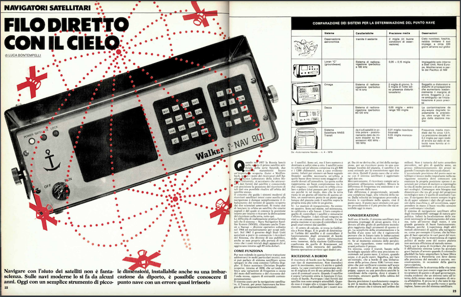
Navigating with the help of satellites is not science fiction. On modern ships it has been done for some years. Today with a simple, small instrument that can be installed even on a pleasure craft, it is possible to know the ship’s point with almost negligible error.
When Russia launched the first artificial satellite of the Sputnik series into space in 1957, two U.S. scholars made an important discovery. Guier and Weiffenback, these are the names of the researchers from theAppliede Physics Laboratory at Johns Hons University, realized that through the data provided by the satellite and by knowing precisely the position of the receiver of that data it was possible to trace the orbit of the satellite itself. The concept that drives modern satellite receiver systems intended as navigation aids is thus simply the reversal of the terms of what the two American scientists discovered. That is, it is a matter of launching into orbit a satellite that emits signals and whose position is known moment by moment and deriving the location of the receiver on the earth, that is all. The difficulties of practical implementation were such that the Navy Navigation Satellite System (NNSS), also called Transit or Navsat, became operational only in 1964 and exclusively for military purposes. In 1967, the U.S. government authorized receivers of the System to be placed on the market, which became for public use, although not exactly affordable, since the initial costs of the devices were around $85,000.
How the system works
While not wishing in this brief discussion to go into much technical detail, one cannot talk about satellite systems without explaining what the Doppler effect consists of. The Austrian physicist Christian Doppler discovered around 1830 that a wave undergoes a change in frequency due to the motion of either the emitter or the receiver of the wave, or both at the same time. The system used for satellite navigation, Transit, needs three basic components to function:
1) The satellites. There are six, but their number is set to rise to eight. The satellites are in orbit at an altitude of 800 to 1200 kilometers, not by chance evidently. In fact, to obtain a good Doppler signal would require an orbit at low altitudes where, instead, disturbances due to the atmosphere are greater. The chosen altitude represents a good compromise between the two requirements. The satellites are in a circular and polar orbit (i.e., they pass through the poles) and this is because in this way, as the earth rotates in a day within this orbit, an observer placed anywhere on the planet sees the satellite over his head several times in a day.

2) The tracking stations. There are four of them. They are in Maine, Minnesota, California and Hawaii. Their job is to monitor satellites and measure their Doppler effect. The measured data are sent to a common computer center. A special station is in charge of monitoring the time signals emitted by the satellites.
3) The computer center. is located in California at Point Mugu. It is able to determine the orbit of the satellite and monitor the operation of the satellite’s on-board instruments. All this information is fed, by the California station assisted by the Rosemount station in Minnesota, into the satellite’s memory. This operation takes place every twelve hours.
Reception on board
The on-board receiver does not need any kind of maintenance. Since there are no moving parts, there is no friction and therefore no wear and tear. Manufacturers assure tens of thousands of hours of use before any failure occurs. When the satellite is above the horizon, the on-board receiver comes into operation. Unfortunately, the data provided by the satellite is not always reliable. When it is too high or too low over the horizon, it is not usable for our purposes. From this it follows that, for navigation purposes, for a receiver placed at any location on the planet, the satellite is in the optimum area for transmission about every two hours. Thus, the ship point that is obtained with the satellite system is updated every two hours. Mechanically, the receiver performs a fairly simple operation. It measures the difference in frequency between emission and signal received by the ship. This difference is proportional, according to a complex law, to the speed of the ship. From the speed an integrator provides the coordinates in space, i.e., the ship’s point, The ship’s point obtained by this procedure is the most accurate that can be obtained at sea today.
Some considerations
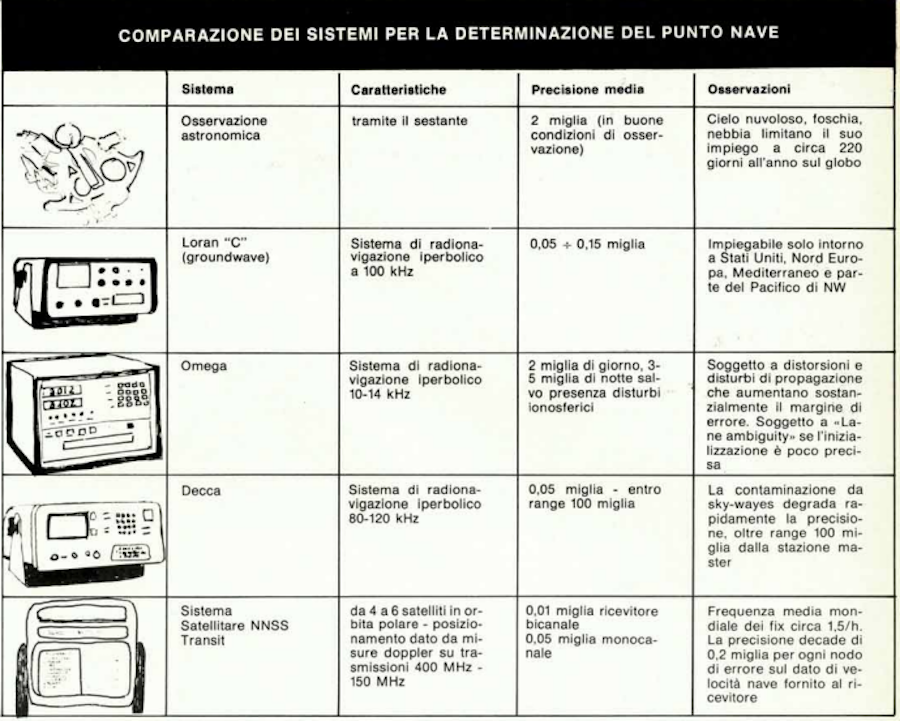
In on-board use, the satellite system has no disadvantages of any kind. This is due to the high degree of technological perfection achieved by instruments of this type. The simplicity of the instrumentation and the ease of use are such that it is reasonable to assume that in the future all vessels will mount a satellite receiver on board. If there are concerns at present, they concern, as we shall see later, only the price. A system, such as Transit, based on space technology offers exceptional accuracy on the ship’s point. The error, when it exists, is only a few meters. It means, to give an example, that on board a first-class IOR vessel the maximum error that can occur is to have the ship’s point of the bow instead of the stern; or on an oil tanker instead of the coordinates of the deck, where the receiver is located, get those of the master’s cabin. This accuracy is absolutely exaggerated for recreational boating, even in relation to the price, which is still in the millions. However, it is not entirely far-fetched to predict, within a few years, a major price reduction following the example of microcomputers. On the other hand, the exceptional accuracy of the satellite ship point is very important in ocean navigation where knowing one’s position exactly is often essential to avoid endangering the lives of many people or causing ecological disasters. However, it should never be forgotten that among the purposes of technological progress is not to replace man. The navigator must always be able to be able to evaluate the data provided to him by the machine and, if necessary, be able to pick up the good old sextant to compare the results. The satellite navigation system offers incomparable geopolitical advantages. In fact, the location of the stations necessary for the system to function, all within the United States, is a great guarantee of smooth operation. Let’s see why. The experience of other electronic methods of navigational aids, such as Loran, for example, which needs operational bases in various countries of the world, teaches us that the mutability of political regimes in many parts of our planet does not ensure efficiency for the method itself. It will be worth mentioning here that the very widespread Loran system suffered serious setbacks when Colonel Qaddafi had the Libyan base dismantled (rebuilt in Pantelleria with slight damage to the accuracy of the method) and again, later, during the Turkish Cypriot war. Given that the safety of human life at sea cannot be subject to the bad character of this or that ruler, it is evident that a system all within the same state is synonymous with sure reliability. And proof of this is that all the world’s navies, from Russian to British, make use of the satellite system.
By Luca Bontempelli
Check out the latest issue


Michele Molino, nautical engineer with the sea in his vein
On the occasion of the 50th anniversary of the Journal of Sailing, the great excellences of the sailing world tell their stories and reveal their projects. In this column, discover all the companies and people who have made important contributions

1985. The sails of the future are being born. The GdV is in, with Lowell North
Welcome to the special section “GdV 5th Years.” We are introducing you, day by day, An article from the archives of the Journal of Sailing, starting in 1975. A word of advice, get in the habit of starting your day

Marinedi, the integrated hospitality system
On the occasion of the 50th anniversary of the Journal of Sailing, the great excellences of the sailing world tell their stories and reveal their projects. In this column, discover all the companies and people who have made important contributions

Naval revolution goes through Judel/Vrolijk study
On the occasion of the 50th anniversary of the Journal of Sailing, the great excellences of the sailing world tell their stories and reveal their projects. In this column, discover all the companies and people who have made important contributions
